วันจันทร์ที่ 14 กรกฎาคม พ.ศ. 2557

Koh Kood


Far quieter and less developed than neighboring Koh Chang, Koh Kood is a pristine island ideal for a relaxing beach holiday.Just south of Koh Chang, its more popular neighboring island, Koh Kood is far less developed and consequently more idyllic. A rather flat island covered almost entirely with native forest or coconut and rubber plantations, Koh Kood has a number of pristine beaches with crystal clear water. Koh Kood is located near the Cambodian border and consequently has an ethnically mixed population of roughly 2,000 residents that is slowly transitioning from an exclusive plantation and fishing economy to an incipient tourism oriented one. Development of accommodation on Koh Kood has focused on attracting a middle and upper class Thai clientele that is drawn by the island’s beauty and tranquility. Both 4-5 hour slow boats and one hour speedboats from Laem Ngob and Dan Kao Piers in Trat Province provide service to the island though nicer resorts have their own boat service. Despite being the fourth largest island in Thailand, Koh Kood has managed to remain an unspoiled slice of tropical heaven. Located in Trat Province, Koh Kood is the southernmost of the Koh Chang island chain. With gorgeous beaches and little other infrastructure it’s a resort destination that caters to those looking for a quiet beach paradise, with soft sand, crystal clear water, and little else. Relaxing is the predominate activity on this island, whose unspoiled nature and leisurely local lifestyle are the prime attractions. Snorkeling or exploring the islands beaches and forests are activities for the more adventurous, although boat trips to nearby islands for sightseeing, snorkeling, and scuba diving are also options. A small fishing village, located at Ao Salat on the Northeast of the island, provides an opportunity to experience island culture.

Bing Translate
Mucho más tranquilo y menos desarrollaron que el vecino Koh Chang, Koh Kood es una prístina isla ideal para unas relajantes vacaciones.Al sur de Koh Chang, su isla vecina más popular, Koh Kood es mucho menos desarrollados y en consecuencia más idílico. Una isla bastante plana cubierta casi en su totalidad con bosque nativo o plantaciones de coco y caucho, Koh Kood tiene un número de playas con aguas cristalinas. Koh Kood está situado cerca de la frontera con Camboya y en consecuencia ha una población étnica de aproximadamente 2.000 residentes que lentamente está en transición de una plantación exclusiva y economía pesquera a un incipiente Turismo orientado a uno. Desarrollo de alojamiento en Koh Kood ha concentrado en atraer una media y clase alta clientela tailandés que es atraído por la belleza y tranquilidad de la isla. Ambos 4-5 horas lentas barcos y lanchas rápidas de una hora de Laem Ngob y Dan Kao muelles en la provincia de Trat proporcionan servicio a la isla aunque mejor Resort tiene su propio servicio de barco. A pesar de ser la cuarta isla más grande de Tailandia, Koh Kood ha logrado permanecer una rebanada vírgenes del paraíso tropical. Situado en la provincia de Trat, Koh Kood es la más meridional de la cadena de la isla de Koh Chang. Con hermosas playas y poco otras infraestructuras es un destino turístico que abastece a aquellos que buscan un paraíso playa tranquila, con arena suave de aguas cristalinas y poco más. Relajarse es la actividad predominante en esta isla, cuya naturaleza virgen y tranquilo estilo de vida es los principales atractivos. Snorkeling o explorar las playas de las islas y los bosques es las actividades para los más aventureros, aunque viajes en barco a las islas cercanas para consejos, snorkel y buceo son también opciones. Un pequeño pueblo de pescadores, situado en el Ao Salat al noreste de la isla, ofrece la oportunidad de experimentar la cultura de la isla.

Thai - Lao Friendship Bridge


Thai-Lao Friendship Bridge is the first international bridge across Mekong River which was jointly built by the governments of Australia, Thailand and Laos. It was opened in April 8, 1994.

Bing Translate
Puente de la amistad de Tailandia y Laos es el primer puente internacional a través del río Mekong que fue construido conjuntamente por los gobiernos de Australia, Tailandia y Laos. Fue inaugurado en 08 de abril de 1994.

Phu Pha Man National Park


Taking the total area of 218,750 Rai, the park covers areas in Amphoe Phu Pha Man and Amphoe Chum Phae of Khon Kaen as well as Amphoe Phu Kradueng in Loei province. The natural landmark of this park is the towering limestone cliff that looks like a huge curtain. The lush jungle and mixed forest keep this place cool almost all the year round. Attractions in this national park include;
            Tham KlangKhao: The cave is in Phu Pha Man Mountain, 2.5 kilometres from Amphoe Phu Pha Man where the entrance is around 100 meters above ground level. Inside is the habitat of millions of bats, which its accumulated droppings caused a very strong smell. Every evening, around 6pm, these bats will leave the cave in line which takes around 30-45 minutes until the last bat leaves the cave, over 10 kilometers long.
            Tham Phra: Next to Tham Klangkhao, this cave has a natural tunnel sloping up to the crest of Phu Pha Man, but it is quite difficult to get through. The cave houses beautiful stalagmites, stalactites, and big stone pillars where the entrance is accessible by car in any season. Winter, from November to February, is the best period to visit the cave.
            Tham Pu Ta Lo: The cave is in Ban Wang Sawap, 17 kilometres from Amphoe Phu Pha Man. Cars can access to the entrance only in summer from November-April. The cave has a spacious chamber, covering over a 1 Rai area. With flat soil ground and 5-7 meter high ceiling, good ventilation allows visitors to enjoy admiring the cave comfortably. Stalagmites and stalactites remain untouched. Some glittering stones look like rock crystals.
            Namtok Tat Fa: Tat Fa creek is the natural borderline between Amphoe Phu Pha Man of Khon Kaen and Amphoe Nam Nao of Phetchabun, cascades through five steps to form this waterfall. The last step is the most impressive one with a height of 80 meters. In the rainy season, from late May to early October is the best period to visit the waterfall. Namtok Tat Fa is in Ban Dong Sakhran, Mu 7 Tambon Wang Sawap, around 40 kilometers from Amphoe Phu Pha Man. Cars can reach Ban Tat Fa, but then visitors have to trek to the waterfall.
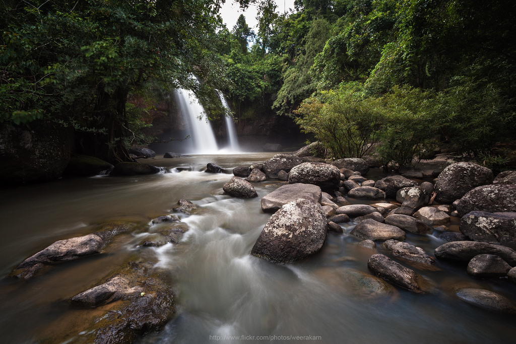
            Namtok Tat Yai: The big waterfall originates from Tat Fa Creek. The creek cascades through small waterfalls before going through a big cliff at 80 meters high. Namtok Tat Yai is the highest waterfall in the park.
            Namtok Tat Rong: With the height of 60-70 meters, the waterfall originates from Phong River that runs from Phu Kradueng. The waterfall borders Phu Kradueng National Park and Phu Pha Man National Park. The ancient myth said that the waterfall can sing as water runs upon a piece of thin stone, the falling water veers off into different rock holes nearby and fills the forest with strange sounds.
            Tham Phaya Nakharat: As winding as a giant naga, the one-kilometer long cave is naturally decorated with glittering curtain-like stalagmites and stalactites. Cars can access up to the entrance.
            Tham Lai Thaeng: Some 800 meters from Tham Phaya Nakharat is Tham Lai Thaeng which wall has ancient paintings throughout around two-square meter area. The paintings contain 70 pictures of humans, animals, and others, reflects culture and life in the pre-historical period back to over 2,000 years ago.
The national park has not any accommodation and facility for tourists. Visitors should prepare everything by themselves.
            Pu Lup: The cave is on Highway 201. Its five chambers are all decorated with glittering stalagmites and stalactites. The cave contains water the year round.
            Pha Nok Khao: The towering cliff of black rock by the Phong River looks like an owl or Nok khao in Thai. It is 125 kilometers from Khon Kaen. Tourists can get there through Highway 2 and 201 (Khon Kaen-Wang Saphung) which Pha Nok Khao is on the left of Ban Dong Lan. The best location to see the owl-shape cliff is at the orchid nursery of the Forestry Department on the other side of the road.

There is another nearby place known as Namtok Tat Ron, or Namtok  Tat Hong in local dialect. The 70-matre high waterfall is located in neighboring Loei province on the boundary of Phu kradueng national Park, Phu Pha Man National Park and the Phong River. The sound made by the waterfall when cascading onto a huge a large stone slab beneath is how the waterfall derived its name.

Bing Translate
Tomando el área total de 218.750 Rai, el parque cubre áreas en Amphoe Phu Pha Man y Amphoe Chum Phae de Khon Kaen, así como Amphoe Phu Kradueng en la provincia de Loei. El monumento natural de este parque es el imponente acantilado de piedra caliza que luce como una enorme cortina. La exuberante selva y bosque mixto refrigerar este lugar casi todo el año. Lugares de interés en este parque nacional;
Tham KlangKhao: La cueva está en Phu Pha hombre montaña, 2,5 kilómetros de Amphoe Phu Pha Man donde la entrada es alrededor de 100 metros sobre el nivel del suelo. En el interior es el hábitat de millones de murciélagos, que sus excrementos acumulados causaron un olor muy fuerte. Cada noche, alrededor de 18, estos murciélagos saldrá de la cueva en la línea que toma alrededor de 30-45 minutos hasta que el último murciélago sale de la cueva, más de 10 kilómetros de largos.
Tham Phra: Al lado de Tham Klangkhao, esta cueva tiene un túnel natural pendiente hasta la cresta de Phu Pha Man, pero es bastante difícil de superar. La cueva alberga hermosas estalagmitas, estalactitas y grandes pilares de piedra donde la entrada es accesible en coche en cualquier época del año. El invierno, desde noviembre hasta febrero, es la mejor época para visitar la cueva.
Tham Pu Ta Lo: La cueva está en Ban Wang Sawap, 17 kilómetros de Amphoe Phu Pha Man. Cars pueden acceder a la entrada solamente en verano desde noviembre a abril. La cueva tiene un compartimiento espacioso, recorriendo más de un área de Rai 1. Con suelo plano tierra y techo de 5 a 7 metros de alto, buena ventilación permite al visitante disfrutar admirando la cueva cómodamente. Estalagmitas y estalactitas permanecen intactas. Algunas piedras brillantes parecen cristales de roca.
Namtok Tat Fa: Tat Fa creek es el límite natural entre Amphoe Phu Pha Man de Khon Kaen y Amphoe Nam Nao de Phetchabun, cascadas a través de cinco pasos para formar esta cascada. El último paso es una impresionante con una altura de 80 metros. En la temporada de lluvias, desde finales de mayo a principios de octubre es la mejor época para visitar la cascada. Namtok Tat Fa está en Ban Dong Sakhran, Mu 7 Tambon Wang Sawap, unos 40 kilómetros de Amphoe Phu Pha Man. Cars puede llegar a Ban Tat Fa, pero luego los visitantes tienen a la caminata a la cascada.
Yai Namtok Tat: La gran cascada origina Tat Fa Creek. El arroyo cascadas a través de pequeñas cascadas antes de pasar por un precipicio de 80 metros de altura. Namtok Tat Yai es la cascada más alta del parque.
Rong Namtok Tat: Con la altura de 60-70 metros, la cascada origina de Phong río que corre de Phu Kradueng. La cascada de fronteras Phu Kradueng Parque nacional y Parque Nacional de Phu Pha hombre. El antiguo mito dice que la catarata puede cantar como agua corre sobre un pedazo de piedra fina, la caída de agua desvía en agujeros de diferentes rocas cercanas y el bosque llena de ruidos extraños.
Tham Phaya Nakharat: Tan sinuoso como un gigante naga, el kilómetro larga cueva naturalmente está decorada con brillantes como cortina de estalagmitas y estalactitas. Pueden acceder a los coches hasta la entrada.
Tham Lai Thaeng: Es de unos 800 metros de Tham Phaya Nakharat Tham Lai Thaeng que la pared tiene antiguas pinturas durante alrededor de dos cuadrados área del metro. Las pinturas contienen 70 imágenes de seres humanos, animales y otros, refleja la cultura y la vida en el período prehistórico regresar hace 2.000 años.
El Parque nacional tiene ningún alojamiento y facilidad para los turistas. Los visitantes deben preparar todo por sí mismos.
PU Lup: La cueva es sobre autopista 201. Sus cinco salas decoradas con estalactitas y estalagmitas brillantes. La cueva contiene agua el año.
PHA Nok Khao: El imponente acantilado de roca negra por el río Phong parece un búho o khao Nok en tailandés. Se encuentra a 125 kilómetros de Khon Kaen. Los turistas pueden llegar a través de la carretera 2 y 201 (Khon Kaen-Wang Saphung) que Pha Nok Khao está a la izquierda de Ban Dong Lan. La mejor ubicación para ver el acantilado buho forma está en el orquidiario del Departamento Forestal del otro lado de la carretera.

Hay otro cercano lugar conocido como Namtok Tat Ron o Namtok Tat Hong en dialecto local. La cascada alta 70-matre está situada en la vecina provincia de Loei en el límite de Phu kradueng national Park, Parque Nacional de Phu Pha hombre y el río Phong. El sonido de la cascada cuando en cascada sobre un enorme una gran losa de piedra debajo es cómo la cascada derivó su nombre.

วันอาทิตย์ที่ 13 กรกฎาคม พ.ศ. 2557

Chet Sao Noi Waterfall National Park


Chet Sao Noi is a small waterfall in Tambon Muak Lek, on the same route as Namtok Muak Lek. The waterfall flows along a stream and has 7 tiers. The height of each tier is approximately 4 meters, with spacious, shaded swimming areas available underneath.
To get there, take the Muak Lek route on Highway No. 2224. Along the route to the waterfall lies a brook, as well as many private resorts.

Bing Translate
Chet Sao Noi es una pequeña cascada en Tambon Muak Lek, en la misma ruta de Namtok Muak Lek. La cascada fluye a lo largo de un arroyo y tiene 7 niveles. La altura de cada nivel es aproximadamente 4 metros, con áreas amplias y sombreadas natación disponibles debajo.
Para llegar allí, tomar la ruta Muak Lek en carretera Nº 2224. A lo largo de la ruta a la cascada se encuentra un arroyo, así como numerosas estaciones privadas.

Sunflower Fields


During the winter months of November and December, cheery yellow sunflower fields spring up along the Phatthana Nikhom-Wang Muang Road, offering a relaxing distraction to those passing by.
The hardy flowering plants are usually grown as a substitution crop for off-season rice fields or other crop fields. They are an economically valuable plant providing not only benefits from harvesting, but also generating income from tourism. Sunflowers are the source of delicious dried sunflower seeds, sunflower seed cookies, chips, crispy sheets, sunflower honey, bee pollen, royal jelly, and more.
The fields are found between Lop Buri and Saraburi, along the Phatthana Nikhom–Wang Muang route.

Bing Translate
Durante los meses de invierno de noviembre y diciembre, campos de girasoles amarillos alegres surgen a lo largo de la carretera Phatthana Nikhom-Wang Muang, ofreciendo una distracción relajante a quienes pasan.
Las angiospermas hardy se cultivan generalmente como un cultivo de substitución para los campos de arroz fuera de temporada u otros campos de cultivo. Son una planta económicamente valiosa proporcionando no sólo beneficios de cosecha, pero también generar ingresos por el turismo. Los girasoles son la fuente de deliciosas semillas de girasol secas, galletas de semillas de girasol, chips, crujientes hojas, miel del girasol, polen de abeja, jalea real y más.
Los campos se encuentran entre Lop Buri y Saraburi, a lo largo de la ruta Phatthana Nikhom – Wang Muang.

วันพุธที่ 9 กรกฎาคม พ.ศ. 2557

Koh Phangan


Other than the full moon party, there are a number of attractions on Koh Phangan, not least of which are dozens of spectacular beaches and bays. The snorkeling and diving around Koh Phangan are both quite good so there are numerous underwater attractions, and the interior of the island features many beautiful waterfalls.

Bing Translate
Aparte de la full moon party, hay varios lugares de interés en Koh Phangan, no menos importante de los cuales son decenas de espectaculares playas y bahías. El snorkeling y el buceo en Koh Phangan son bastante buenos por lo que hay numerosas atracciones submarinas y el interior de las características de la isla muchas hermosas cascadas.

Koh Samui


History of Koh Samui
According to the evidence found on Samui Island, historians believe that it was first inhabited by man at most 1,200 years ago. In 1940s, the island was still isolated from the outside world. Those wishing to travel to Samui had to travel from Surat Thani for approximately 6 hours. As in-land transportation was not well established, it took several hours for people to walk through the lush jungles to the beach. It was only in the early 1970’s that Koh Samui became a dream destination discovered by backpackers.
With the development of infrastructure, an increasing number of travelers were attracted to the island. Samui’s concrete ring road was finished in 1973 by the order of the government. Passing beautiful beaches around the island and connecting sub-district areas, the road facilitated tourism. The Tourism Authority of Thailand explored the island in 1980 and realizing the high tourism potential of Samui, a plan to develop and promote tourism on the island was implemented. As a result, it has become and will continue to be a popular tourist destination in Thailand.
Koh Samui is located in the Gulf of Thailand, approximately 84 kilometers east of Surat Thani Province, or approximately 700 kilometers south of Bangkok. Known as the Coconut Island, Koh Samui is one of the most famous and popular attractions of Thailand. With an area of 247 square kilometers, Koh Samui is the third largest island of Thailand after Phuket and Koh Chang (of Trat Province). The topography of the island is that of a plain with a mountain range in the middle and 7 important streams. In addition, there is a 50-kilometer paved road that encircles the island. Moreover, the area of the island stretches to a group of 48 surrounding islets.
Despite the fast pace of development, Koh Samui has been able to maintain its charm its classical image of a tropical beach resort fringed by coconut trees. Travelers to the island can enjoy a mixed blessing of vibrant day and nightlife along side with tranquility which can easily be found across different parts of Koh Samui as the archipelago is a peaceful home for fishermen and a natural den for seagulls and other rare birds.
Hat Chaweng and Hat Lamai are Koh Samuis most beautiful and most popular beaches. Both have a huge selection of accommodations suitable for every budget. Please note that room rates increase during the high season, from December to July, when Samui sparkles. The nightlife of each beach is different: Hat Chaweng is better for couples, women and families, while single men are drawn to the beer bar culture of Hat Lamai. These resorts, as well as Na Thon (Samui’s main town), have communications, exchange and car/motorcycle hire facilities. Other beaches include Hat Choeng Mon, Hat Mae Nam in the north and Hat Na Thon, the island’s major seafront settlement where shops, restaurants and tour agencies are concentrated.
Apart from its many lovely beaches and tranquil bays, Koh Samui is also noted for its high quality coconuts that grow densely everywhere. The best time to visit Koh Samui is from February to April when the sea is calm. The Southern dialect and the standard Thai language are spoken while English is widely understood in tourist areas.

Bing Translate
Historia de Koh Samui
Según las pruebas encontradas en la isla de Samui, los historiadores creen que primero fue habitada por el hombre hace a más de 1.200 años. En la década de 1940, la isla era todavía aislada del mundo exterior. Aquellos que deseen viajar a Samui tuvieron que viajar desde Surat Thani durante aproximadamente 6 horas. Como transporte de tierra no estaba bien establecida, tomó varias horas para la gente a caminar por la selva exuberante a la playa. Fue sólo en principios de los setenta que Koh Samui se convirtió en un destino de ensueño descubierto por los mochileros.
Con el desarrollo de infraestructura, un creciente número de viajeros se sintieron atraído a la isla. Circunvalación concreto de Samui terminó en 1973 por orden del gobierno. Pasando por hermosas playas alrededor de la isla y áreas del subdistrito de conexión, el camino facilitado turismo. La autoridad de Turismo de Tailandia exploró la isla en 1980 y al darse cuenta del potencial turístico alta de Samui, se implementó un plan para desarrollar y promover el turismo en la isla. Como resultado, se ha vuelto y seguirá siendo un destino turístico muy popular en Tailandia.
Koh Samui se encuentra en el Golfo de Tailandia, aproximadamente 84 kilómetros al este de la provincia de Surat Thani, o aproximadamente 700 kilómetros al sur de Bangkok. Conocida como la isla del coco, Koh Samui es una de las atracciones más famosas y populares de Tailandia. Con una superficie de 247 kilómetros cuadrados, Koh Samui es la tercera mayor isla de Tailandia después de Phuket y Koh Chang (de la provincia de Trat). La topografía de la isla es la de una llanura con una cadena montañosa en los medios y 7 arroyos importantes. Además, hay un camino pavimentado de 50 kilómetros que rodea la isla. Por otra parte, la zona de la isla se extiende a un grupo de 48 rodean islotes.
A pesar del rápido ritmo de desarrollo, Koh Samui ha sido capaz de mantener su encanto su imagen clásica de un resort de playa tropical bordeado por árboles de coco. Los viajeros a la isla pueden disfrutar una bendición del día vibrante y vida nocturna junto con tranquilidad que fácilmente se puede encontrar en diferentes partes de Koh Samui como el archipiélago es un hogar tranquilo para los pescadores y una cueva natural de gaviotas y otros pájaros raros.
Sombrero de Chaweng y Lamai sombrero son Koh Samuis más bellos y las playas más populares. Ambos tienen una gran selección de alojamientos adecuados para todos los presupuestos. Por favor tenga en cuenta que las tarifas aumentan durante la temporada alta, de diciembre a julio, cuando brilla Samui. La vida nocturna de cada playa es diferente: Hat Chaweng es mejor para las parejas, mujeres y familias, mientras que los hombres solteros se sienten atraídos por la cultura de bar de cerveza de Hat Lamai. Estos centros, así como Na Thon (ciudad principal de Samui), tienen comunicación, intercambio y contratar servicios de coche/moto. Otras playas son sombrero Choeng Mon, sombrero Mae Nam en el norte y sombrero Na Thon, establecimiento de gran paseo marítimo de la isla donde se concentran tiendas, restaurantes y agencias de viajes.
Aparte de sus muchas hermosas playas y bahías tranquilas, Koh Samui es también conocida por sus cocos de alta calidad que crecen densamente por todas partes. La mejor época para visitar Koh Samui es de febrero a abril, cuando el mar está tranquilo. Mientras que el inglés es ampliamente entendido en las zonas turísticas se hablan el dialecto del sur y el idioma tailandés estándar.

วันอังคารที่ 8 กรกฎาคม พ.ศ. 2557

Bua Tong Fields at Doi Mae U-Kho


The Dok Bua Tong (may be classified as wild sunflowers) blooms during November painting the entire hilly area of Doi Mae U-kho in brilliant yellow draw flocks of visitors to Khun Yuam district. Camping sites arranged during the Bua Tong Bloom Festival is 26 kilometers from the district on Highway No. 1263.

Bing Translate
El Dok Bua Tong (pueden ser clasificados como girasoles silvestres) florece durante noviembre pintar el área montañoso entero de Doi Mae U-kho en bandadas sorteo amarillo brillante de los visitantes de distrito Khun Yuam. Sitios de camping organizado durante el Festival de floración Bua Tong es 26 kilómetros del distrito de carretera Nº 1263.

Promthep Cape


Most photographs of the stunningly beautiful sunset in Phuket were taken here: Laem Phromthep at the south-most tip of Phuket island offers a memorable, unparalleled sunset moment on a clear day. Go early and sit back to enjoy the sun setting behind the Andaman sea. With its landscape easily recognizable by sailors, it is also the location of the 50-feet-tall Kanchanapisek Lighthouse, erected in 1996 to celebrate the auspicious occasion of the king’s 50th anniversary of his accession to the throne.

Bing Translate
Del bello atardecer en Phuket, la mayoría de las fotografías fueron tomada aquí: Laem Phromthep en la punta más meridional de la isla de Phuket ofrece un momento inolvidable, inigualable puesta del sol en un día claro. Temprano y sentarse a disfrutar de la puesta de sol detrás del mar de Andamán. Con su paisaje fácilmente reconocible por los marineros, es también la ubicación del faro de Kanchanapisek 50-pies de altura, construido en 1996 para celebrar la ocasión propicia de aniversario de su accesión al trono del rey.

Heo Suwat Waterfall


Heo Suwat Waterfall—HeoSuwat Waterfall (NamtokHeoSuwat)—This is a famous waterfall that cascades from a 20-meters high cliff. The waterfall, which is located at the end of Thanarat Road and being accessible by car, is only 100 meters by foot from the parking lot or a 3-kilometer walk from PhaKluai Mai Waterfall. Visitors can view the falls from a distant viewpoint that offers a high-angle view of the waterfall through the trees or from the waterfall itself. However, please note that in the rainy season the water flows rapidly and caution should be taken.

Bing Translate
Heo Suwat cascada, cascada de HeoSuwat (NamtokHeoSuwat) — es una famosa cascada que cae desde un acantilado de 20 metros. La cascada, que se encuentra al final de Thanarat Road y ser accesible en coche, está a sólo 100 metros a pie desde el estacionamiento o en un paseo de 3 kilómetros de PhaKluai Mai cascada. Los visitantes pueden ver las cataratas desde un punto de vista distante que ofrece una vista de ángulo alto de la catarata a través de los árboles o de la cascada de sí mismo. Sin embargo, tenga en cuenta que en la temporada de lluvias el agua fluye rápidamente y deben tomar precauciones.

Sanctuary of Truth


The Sanctuary of Truth or Vihan Sajjadham is the giant temple-like structure entirely made of wood situated by the sea at Laem Ratchawet on Na Klua Road, North Pattaya covers an area of more than 3,200 sq. meters,. It was constructed according to ancient Thai ingenuity to withstand wind and sunshine on the seashore with 105 meters top at the highest point. Its exquisite architectural features were conceived out of the vision that human civilization has been achieved and nurtured by religious and philosophical truths with the reflection of ancient vision and eastern philosophy. There is also Dolphin Training Shows at 11.30 am and 3:30pm.

Bing Translate
El Santuario de la verdad o Vihan Sajjadham es el templo-como la estructura gigante hecha de madera situado junto al mar en Laem Ratchawet en Na Klua Road, North Pattaya cubre un área de más de 3.200 metros cuadrados. Fue construido según antiguo ingenio tailandés para soportar el viento y el sol en la orilla del mar con la tapa de 105 metros en el punto más alto. Sus exquisitas características arquitectónicas fueron concebidos fuera de la visión que la civilización humana ha sido lograda y alimentados por las verdades religiosas y filosóficas con la reflexión de la antigua visión y filosofía oriental. También hay delfines formación muestra a 11:30 y 15:30.

วันจันทร์ที่ 7 กรกฎาคม พ.ศ. 2557

Wat Phra That Doi Suthep


Perhaps the most famous and important temple in Chiang Mai every visitor must pay a visit. On top of Doi Suthep Hill, at 3,520 feet above sea level, finds the revered golden Phra That (chedi) of Wat Phra That Doi Suthep rises against the sunlight. The temple was built in 1383 to enshrine Buddha’s relics. You can actually drive uphill to the higher platform but a lot of  devout Buddhists choose to pilgrim by walking 290 steps up to the hilltop. After praying the Phra That for good lucks, don not forget to proceed to the terrace to soak up panoramic views of Chiang Mai town and surrounding countrysides.

Bing Translate
Tal vez el más famoso e importante templo en Chiang Mai cada visitante debe pagar una visita. Colina Doi Suthep, a 3.520 metros sobre el nivel del mar, se encuentra el venerado oro Phra ese (chedi) de Wat Phra que Doi Suthep subidas contra la luz del sol. El templo fue construido en 1383 para venerar las reliquias del Buda. Usted en realidad puede conducir cuesta arriba a la plataforma superior pero muchos devotos budistas elegir Peregrino Caminando 290 pasos hasta la colina. Después de rezar el Phra que por buenas suertes, no olvide don proceder a la terraza para disfrutar de vistas panorámicas de la ciudad de Chiang Mai y los campos circundantes.

วันพฤหัสบดีที่ 3 กรกฎาคม พ.ศ. 2557

Heo Narok Waterfall


Located to the south of a park, this beautiful triple-tiered waterfall cascades from a 200-meter cliff through forested mountains onto plains below. Its first tier is 60 meters high. The scene is breathtaking, particularly with strong currents plunging from the first tier to the lower tiers at a 90-degree angle before disappearing into the deep valley. The waterfall is truly spectacular - and equally dangerous - claiming at least one elephant death per year as wild elephant herds trundle through the waterfall.
The waterfall is accessible via Route No. 3077 (Prachin Buri-Khao Yai Route). Traveling by car from the city, drive along Suwannason Road, take a left turn to Highway Number 3077 at Noen Hom intersection or Naresuan roundabout in Prachin Buri Province, and proceed to the Km. 24 marker. From Bangkok, take the Don Mueang-Hin Kong route and then turn left on to Highway No. 33, which leads to Noen Hom Intersection. Alternatively, take Rangsit Road and drive towards Nakhon Nayok-Noen Hom Intersection, then switch to Highway No. 3077 to Namtok Heo Narok. In addition, there are several bus companies operating on the Bangkok-Prachin Buri route. Buses depart from the Northern Bus Terminal on Kamphaengphet 2 Road. Disembark the bus at Naresuan Intersection and then hire a song taew (or open-air taxi) to Khao Yai National Park.
The waterfall is open to visitors from 8.00 am- 5.00 pm daily.

Bing Translate
Situado al sur de un parque, cascadas de esta hermosa cascada de tres niveles de un precipicio de 200 metros a través de las montañas boscosas en llanuras más abajo. Su primer nivel tiene 60 metros de altura. La escena es impresionante, particularmente con fuertes corrientes cayendo desde el primer nivel a los niveles inferiores en un ángulo de 90 grados antes de desaparecer en el profundo valle. La cascada está verdaderamente espectacular - y es igualmente peligroso - afirmando la muerte de al menos un elefante por año como nido de manadas de elefante salvaje a través de la cascada.
La cascada es accesible a través de ruta nº 3077 (ruta Prachin Buri-Khao Yai). Viajando en coche desde la ciudad, a lo largo de Suwannason Road, gire a la izquierda a carretera número 3077 Noen Hom cruce o rotonda Naresuan en Prachin Buri provincia y proceder al marcador km. 24. Desde Bangkok, tomar la ruta de Don Mueang-Hin Kong y girar a la izquierda por la carretera Nº 33, que conduce a la intersección Noen Hom. Alternativamente, tomar Rangsit Road y conducir hacia Nakhon Nayok-Noen Hom intersección, luego cambiar a la autopista no. 3077 a Namtok Heo Narok. Además, hay varias compañías de autobuses que operan en la ruta Bangkok-Prachin Buri. Los autobuses salen de la Terminal de autobuses del norte en Kamphaengphet 2 Road. Bajar del autobús en la intersección de Naresuan y luego contratar una canción taew (o taxi al aire libre) del Parque Nacional de Khao Yai.
La cascada está abierta a los visitantes de 8.00 am-5.00 pm diariamente.

Phu Ruea National Park


The peak of Phu Ruea (1,365 meters above sea level) has been regarded the coldest location in Thailand during the winter season for several years. Phu Ruea covers an area of approximately 120 square kilometers, featuring cool climate, lush pine forest and beautiful winter flowers. Other attractions include observation points, waterfalls, rock gardens, and caves with highlights such as Pha Lon Noi, which offers a spectacular sunrise and beautiful scenery, Pha Sub Thong, a very steep cliff, Namtok Huai Phai, a 30 meter-high waterfall, and Phu Ruea Summit, which provides a fine view of Huang and Khong Rivers.
The foot of Phu Ruea also finds Chateau de Loei Winery, a huge vineyard with modern wine-making facilities.

Bing Translate
El pico de Phu Ruea (1.365 metros sobre el nivel del mar) ha sido considerado el lugar más frío en Tailandia durante la temporada de invierno desde hace varios años. Phu Ruea cubre un área de aproximadamente 120 kilómetros cuadrados, con clima fresco, bosque de frondosos pinos y flores de invierno hermosa. Otras atracciones incluyen puntos de observación, cascadas, jardines de roca y cuevas con destacan Pha Lon Noi, que ofrece un espectacular amanecer y hermosos paisajes, Pha Sub tanga, un acantilado muy, Namtok Huai Phai, a 30 metros de altura cascada y Phu Ruea Cumbre, que proporciona una buena vista de Khong ríos y Huang.
El pie de Phu Ruea también encuentra bodega Chateau de Loei, un gran viñedo con modernas instalaciones de vinificación.

Phu Hin Rong Kla National Park


Phu Hin Rong Kla National Park covers an area of 191,875 rai or 76,750 acres of land, located 130 kilometers from Phitsanulok town center. The park has many different terrains including waterfalls, lush forests, and plains of rocks with the highest point in the park at 1,617 meters above sea level. There are different types of rock formations with splits in the rocky grounds and uneven formations. The park offers the opportunity to explore many of its historical sites that staged the conflict of two political parties. During 1967-1982, Phu Hin Rong Kla was the headquarters of the Communist Party of Thailand. The area was deemed a red zone by the government and became a battlefield between the Royal Thai Army and the Communist Party for 15 years. Phu Hin Rong Kla was a strategic location due to its mountainous areas which were great for defenses. The conflict ended in 1982 when the government granted amnesty to the students who join the Communist Party of Thailand, resulting in Phu Hin Rong Kla becoming a national park in 1984. Visitors are able to witness the rustic meeting hall, political school, and the administration building. A trail leading to Lan Hin Pum contains rock formations where Communist Party students used them as shelter from air bombing. The nearby headquarters is now a museum that exhibits weapons and medical instruments used by the Communist Party members. Another trail leads to Pha Chu Thong where the Communist Party’s red victory flag is situated. Tourists and visitors may stay overnight with accommodations and tents available but you are advised to make reservations.

Bing Translate
Parque Nacional de Phu Hin Rong Kla cubre un área de 191.875 rai o 76.750 acres de terreno, ubicado a 130 kilómetros del centro de la ciudad de Phitsanulok. El parque tiene muchos diferentes terrenos incluyendo cascadas, bosques y llanuras de rocas con el punto más alto en el parque a 1.617 metros sobre el nivel del mar. Existen diferentes tipos de formaciones rocosas con fracturas en los terrenos rocosos y formaciones irregulares. El parque ofrece la oportunidad de explorar muchas de sus sitios históricos que escenifican el conflicto de dos partidos políticos. Durante 1967-1982, Phu Hin Rong Kla fue la sede del partido comunista de Tailandia. La zona se consideró una zona roja por parte del gobierno y se convirtió en un campo de batalla entre el real ejército tailandés y el partido comunista desde hace 15 años. Phu Hin Rong Kla era un lugar estratégico debido a sus zonas montañosas que eran geniales para las defensas. El conflicto terminó en 1982 cuando el gobierno concedió la amnistía a los estudiantes que se incorporan al partido comunista de Tailandia, resultando en Phu Hin Rong Kla convirtiéndose en un parque nacional en 1984. Los visitantes son capaces de presenciar el salón rústico, la escuela política y el edificio de la administración. Un sendero que lleva a Lan Hin Pum contiene formaciones rocosas donde los estudiantes partido comunista usaban como refugio de bombardeo aéreo. La jefatura de ahora es un museo que exhibe armas e instrumentos médicos usados por los miembros del partido comunista. Otro camino conduce a Pha Chu tanga donde se encuentra la bandera de Victoria roja del partido comunista. Los turistas y visitantes pueden pasar la noche con alojamiento y tiendas disponibles pero se recomienda hacer reservas.